
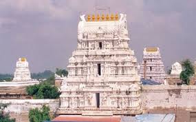
The two week Balaji Jenda Jatara here in the town is about to conclude with the procession of idols of Lord Venkateswara and his two consorts along with a traditional jenda (flag) on Monday.
Shrine’s Map Location and How to Go There

By Road
Nizamabad district has good road connectivity. Almost all the towns and villages in the district have well-laid asphalt roads and are connected to district headquarters. Nizamabad has 2 National Highways passing through it, one being NH 44 which connects Kanyakumari and Varanasi and the other is NH16 which starts from Nizamabad and passes through Karimnagar to Jagadalpur in the state of Chhattisgarh.The Telangana State Road Transport Corporation (TSRTC) runs around 700 buses from district headquarters on a daily basis.
By Rail
Nizamabad Railway Station is the major train station in the district which is located on Secunderabad-Manmad section of Hyderabad Division of the South Central Railway Zone (SCR). Not all the towns in the district have a rail network coverage but Nizamabad being one of the important stations on the line carters the need of the people. Jankampet Junction which lies on the north of Nizamabad city connects to Bodhan town
By Air
The nearest airport is Rajiv Gandhi International Airport Shamshabad Hyderabad.Balaji Jenda Jatara
Events Celebrated at This Shrine
Balaji Jenda Jatara