
The group temples of Jainism are situated on the Girnar mountains in the Junagadh District of Gujarat, India, situated near Junagadh.There are temples on the hill sacred to the Digambara and the Svetambara branches of Jainism.
Shrine’s History
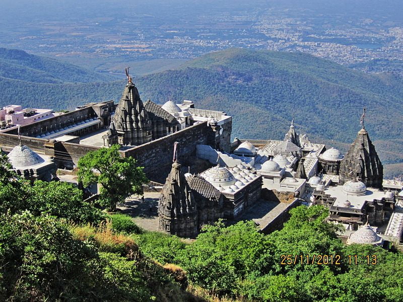
Girnar was anciently called Raivata or Ujjayanta, sacred amongst the Jains to Neminath, the 22nd Tirthankar, and a place of pilgrimage before the days of Ashoka, 250 BCE. Situated on the first plateau of Mount Girnar at the height of about 3800 steps, at an altitude of 2370 ft above Junagadh, still, some 600 ft below the first summit of Girnar, these temples of Jainism have marvelous carvings in marble, which can be compared to those of Delwada near Mount Abu in Rajasthan. These temples attract devotees of both Shwetambar and Digambar sects of Jainism. On entering the gate of Jain complex, the large enclosure of the temples is on the left, while to the right is the old granite temple of Man Singh, Bhoja Raja of Kutch, and farther on the much larger one of Vastupala. Some 16 Jain temples here form a sort of fort on the ledge at the top of the great cliff, but still 600 feet below the summit. The largest temple is the Neminath temple standing in a quadrangular court 195 x 130 feet.
It is built from 1128 to 1159. It consists of two halls, and a shrine, which contains a large black image of Neminath sitting in the lotus position holding a conch in his palm. Round the shrine is a passage with many images in white marble. Between the outer and inner halls are two shrines. The outer hall has two small raised platforms paved with slabs of yellow stone, covered with representations of feet in pairs called padukas, which represent the 2452 feet of the Gandharas, first disciples of Tirthankaras. On the west of this is a porch overhanging the perpendicular scarp. On two of the pillars of the mandapam are inscriptions dated 1275, 1281, and 1278 dates of restoration. The enclosure is nearly surrounded inside by 70 cells, each enshrining a marble image, with a covered passage in front of them lighted by a perforated stone screen.
The principal entrance was originally on the east side of the court, but it is now closed, and the entrance from the court in Khengar’s Palace is that now used. There is a passage leading into a low dark temple, with granite pillars in lines. Opposite the entrance is a recess containing two large black images; in the back of the recess is a lion rampant and over it a crocodile in bas-relief. Behind these figures is a room from which is a descent into a cave, with a large white marble image which is mostly concealed by priests. It has a slight hollow in the shoulder, said to be caused by water dropping from the ear, whence it was called Amijhara, “nectar drop.” In the North porch are inscriptions which state that in Samwat 1215 certain Thakurs completed the shrine, and built the Temple of Ambika. After leaving this there are three temples to the left. That on the Southside contains a colossal image of Rishabha Deva, the first Tirthankar, exactly like that at Palitana temples, called Bhim-Padam. On the throne of this image is a slab of yellow stone carved in 1442, with figures of the 24 Tirthankars.
Opposite this temple is a modern one to Panchabai. West of it is a large temple called Malakavisi or Meravasi, sacred to Parshwanath, built in the 15th century.North again of this is another temple of Parshwanath, which contains a large white marble image canopied by a cobra, whence it is called Sheshphani, an iconology frequently found in the South India but uncommon in the North India. It bears a date of 1803. The last temple to the north is Kumarapala’s temple built by Chaulukya king Kumarapala, which has a long open portico on the West, and appears to have been destroyed by the Muslims, and restored in 1824 by Hansraja Jetha. These temples are along the west face of the hill and are all enclosed. Outside to the north is the Bhima Kunda, a tank 70 feet by 50 feet, in which Hindus bathe. Immediately behind the temple of Neminath is the triple one temple, Vastupala-Tejpala temple, erected by the brothers Tejapala and Vastupala who also built Dilwara Temples on Mount Abu. The plan is that of 3 temples joined together. The shrine has a blue-black image of Mallinath, the 19th Tirthankar. Farther North is the temple of Samprati Raja. This temple is probably one of the oldest on the hill, dated 1158. Samprati is said to have ruled at Ujjain at the end of the third century BCE, and to have been the son of Kunala, Ashoka’s third son. South of this and 200 feet above the Jain temples on way to the first summit is the Gaumukhi Shrine, near a plentiful spring of water.
Shrine’s Map Location and How to Go There

By Road
The nearest Bus stop is Junagadh
By Rail
The nearest Railway station is Junagadh
By Air
The Nearest Airport is Porbandar Airport.