
Shrine’s History
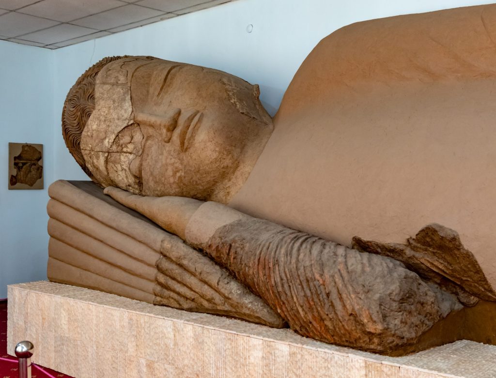
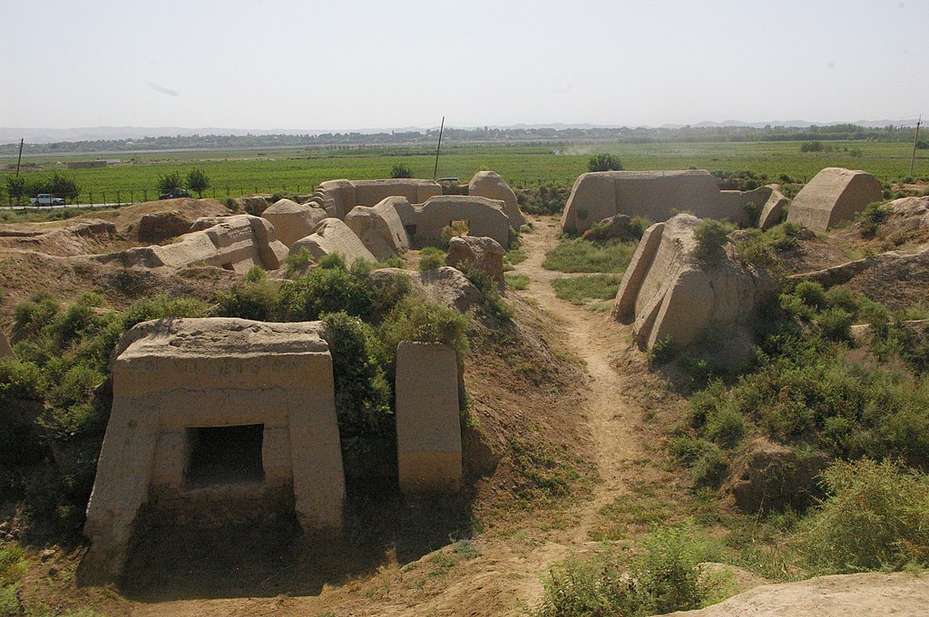
Buddhist site of Ajina Tepe, which dates back to the 7th and 8th centuries, is an earthen site situated in the south of Tajikistan. It was considerably damaged during decades of neglect after the excavations carried out in Soviet times and in dire need of emergency consolidation work. The site possesses great educational potential thanks to the discovery of a very large reclining Buddha statue measuring 12-meters high, among other priceless objects, now displayed in the Tajikistan National Museum of Antiquity in Dushanbe. The physical structure of the Monastery also remains intact
Buddhism in Tokharistan is said to have enjoyed a revival under the Western Turks. Several monasteries dated to the 7th-8th centuries display beautifull Buddhist works of art, such as Kalai Kafirnigan, Ajina Tepe, Khisht Tepe or Kafyr Kala, around which Turkic nobility and populations followed Hinayana Buddhism
lsu jersey
vincha sexy sbelt
vans sandals australia
eiszapfen lichterkette 3m
birkenstock gizeh blau gold
cazadora estilo motero hombre
lyngdorf mp 50 hdmi upgrade
mi box s update
cazadora estilo motero hombre
amazon bodenfliesen bunt
nike survetement
ASU Jerseys
hq8716 Italy
womens air jordans


Architectural Relevance of This Shrine
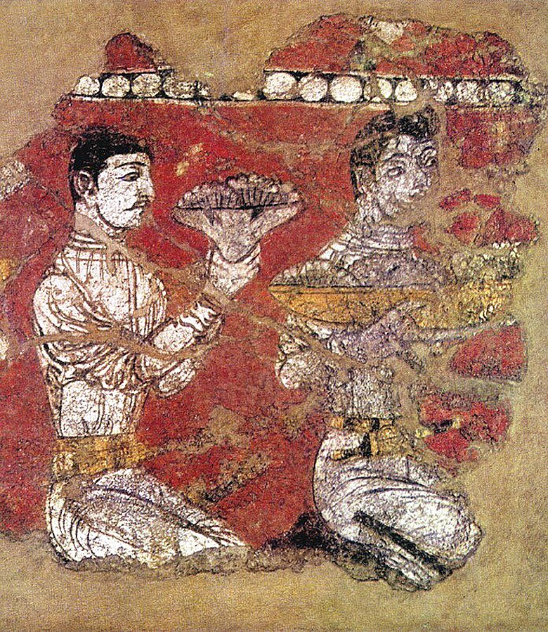
The building discovered during excavations was attributed as a Buddhist monastery. In terms of it consisted of two rectangular courtyards, surrounded by the premises of sanctuaries, cells, corridors, etc. in one of the courtyards was a religious building-a stupa. On Ajina Tepe found murals and clay statues, including a twelve-meter figure of Buddha. The figure lying on its right side in an outstretched position is a traditional statuesque pose known from the stone statues of Buddha in Nirvana. The architecture and decoration of Ajina Tepe organically merged Indian elements and local traditions of ancient Tokharistan
Shrine’s Map Location and How to Go There

By Road
The site is 19km away from Qurghonteppa, Tajikistan. Qurghonteppa or Kurganteppa, officially known as Bokhtar (Tajik: Бохтар), is a city in southwestern Tajikistan, which serves as the capital of the Khatlon region. Qurghonteppa is the largest city of southern Tajikistan, and is located 100 kilometres (62 mi) south of Dushanbe and 150 kilometres (93 mi) north of Kunduz, Afghanistan
BY RAIL
Qurghonteppa train station (AKA “Khatlon Station”) is not in the city, but rather 10km from the city centre, but on a very quick road. There are usually a couple of shared taxis waiting to take people to the city for 5 Somoni per seat (the drivers will call out “Kurgan!” or “bazaar!” or even “shahr” – Tajik for ‘city’). The cars go as far as the old central bazaar of Qurghonteppa/Bokhtar
BY AIR
Qurghonteppa International Airport is the nearest airport this site
Shrine Timings
As this is an open site, it is open all the time
Extra Information About this Shrine
UNESCO, in cooperation with the Japanese Government, has launched several cultural heritage conservation projects along the Silk Roads. Two projects in China (the Longmen Grottoes and the Kumtra Thousand Caves), and three projects in Central Asia (the site of Fayaz Tepe in Uzbekistan, the Otrar project in Kazakhstan, and the Krasnaya Rechka, Chuy Valley sites project in Kyrgyzstan), are already in progress. The recently approved project (April 2005) for the preservation of the Buddhist Monastery of Ajina Tepe in Tajikistan is the last project within this special UNESCO/Japan FIT Silk Roads programme.